Madison Noise Levels Along Transit Lines (2020):
The community of Madison is a residential area governed by strict noise ordinances, prohibiting excessive noise from 10pm to 7am. These ordinances exist to serve residential areas and are therefore looked over by the Zoning and Planning Board. Yet, the noise ordinance mentions nothing of the noise pollution caused by heavily trafficked roads and train lines. However, the noise being produced by these sources are significant, and it has been noted, by organizations such as the EPA, that noise pollution can have a direct effect on quality of life and mental health and is an important factor to consider in residential planning
The modeling of noise can help communities understand the risk associated with noise pollution and its effect on human and environmental health and quality of life. This map uses the most recent transportation noise maps created by US Department of Transportation 2020 to see how these sources of noise exist together in communities around the US in regards to rail noise, road noise, and aviationary noise.
The data present in this map was compiled by Esri’s Living Atlas Environmental Team. The team utilized the US Department of Transportation railroad, road, and aviation noise model along with data from the state level to fill in areas that were not fully covered by the DOT’s work to construct the titled imagery layer visible in figure 1. This data is predicted by a model, as collecting this data countrywide would be infeasible as of now. The Living Atlas team published their compilation of the data as a scientific raster in November of 2022. The dataset can be found online here.
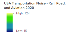
Ledgend describing the noise levels (in dBA) portrayed in the tranist noise level map.
In Madison, the noise produced by transportation routes (NJ Transit Dover Line, busy roads such as Madison Ave., Park Ave., Main St., and Highway 24) the noise predicted by the map produced by DOT’s model spans from 124 dBA to 45 dBA. The areas with the highest predicted decibels is indicated with yellow-green coloration, while areas with lower predicted sound is indicated in deep blue.
Since the Living Atlas team focused on the noise pollution caused by transit, the map displays the noisest areas along the transit lines, which have been mapped as part of the Madison ERI in previous years.
Understanding the current patterns of noise pollution within Madison, NJ can help locate areas of concern regarding the potential negative effects of the pollution. It can aid in personal decision making, whether one chooses to live closer to a louder but more transportation accessible area, or in a further but quieter environment.
Additionally, studies have shown that exposure to loud noise can cause high blood pressure, stress, and sleep disturbance. Therefore the data can serve as beneficial information to the public.
